
I tried an experiment today. I walked out the front door with the goal of walking around the block, defined as:
- walk along the edge of a public roadway, keeping the road to one side (left as I chose) at all times, and
- never cross a public roadway.
I knew the path I would trace, but I’d never actually walked it, in 20 years of living here, for reasons which shall become clear. I tracked my walk in Strava, and the statistics of a walk around my block are:
- Distance: 2.82 km
- Minimum elevation: 48 metres
- Maximum elevation: 87 metres
- Accumulated elevation climb: +67 metres
The path I walked looks like this (I’ve hand drawn it and not provided any street names):
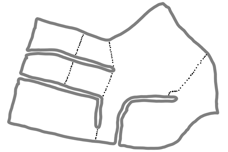
There are three dead end streets running into the interior of the block, so by my rules I had to walk into each one and back out along the opposite side of the street – something I’ve never done before in a single walk. The dotted lines mark pedestrian paths which provide short cuts that vehicles can’t use. Naturally, when I’m out walking I make good use of these short cuts, providing another reason why I’ve never had occasion to walk around the block like this before. The area I live in is very hilly, so there was a lot of elevation change as I traced this route.
Interestingly, I’ve long thought that if I just cross the street directly outside my place, I end up on a block of land that adjoins Sydney Harbour (as in, I can walk from that point to the shore without crossing a road – in fact have done so on many occasions). So if I tried to walk around that block by the same rules, I would end up having to walk all the way around Sydney Harbour, by a route encompassing various bridges (Fig Tree, Tarban Creek, Gladesville, Iron Cove, Anzac, and Sydney Harbour Bridges, for those counting). After doing the simpler block walk today, I checked Google Maps to see exactly what sort of route this enormous walk would take, and I realised that because of various underpasses that go beneath the bridges I was thinking of, I would actually end up either skipping some of the bridges and going even further around, further upriver (ending up crossing the river on Silverwater Bridge, of all things), or doing odd loops that cross a bridge then go around an underpass loop and then go back across the same bridge on the other side of the road.
Ultimately, I traced my path as far as the Sydney Harbour Bridge, which is the only way back to my place from the southern side of the harbour… only to realise that by my rules I would end up doing one of those underpass loops on the north side and then returning to the southern side… now with nothing to return me back to the northern side between there and the ocean. In fact, this “around the block” walk would take me all the way around the entire coastline of mainland Australia before returning to my home.
(In practice, you would be very hard pressed to actually walk this route as it encompasses several freeway sections where pedestrians are banned.)
But I was staggered by the fact that a simple rule mixed with the vagaries of the road system meant that my original assumption of merely walking around the harbour and across a few bridges was mistaken, and that instead it would lead to a grand walk around the whole continent.
If anyone else cares to try this, either with an actual walk, or tracing a route via Google Maps, please let me know your results.
New content today:
I think living so close to the harbor makes you a special case for that second part. I live in a suburban subdivision. Not crossing a street leaves me walking about 930 m in something not-quite-rectangular shaped.
To be able to leave my subdivision, I’d have to cross to the other side of the road directly outside my home, then cross a second road at the end of the block. At that point I would end up walking about 6 km around 3/4 of an oddly-shaped, er, shape before having to turn back down a road into my neighborhood. Then I’d have to follow the perimeter of the neighborhood, walking down and back all the dead ends, until finally returning to the point where the road I live on and that second road I crossed meet. Then I either have to cross those two roads again to go home (which seems fair) or be stuck walking the same route forever.
I wasn’t going to bother measuring that part around the neighborhood, but I was too curious. Doing that walk around the perimeter of the neighborhood very, very, very roughly adds another 10 km!
I got bored at 4 miles, slightly over half way home. There’s dozens of little cul de sacs, some with multiple cul de sacs off them. Fiddling the route down all of them wasn’t worth the effort. Call it seven miles…
The route isn’t one I would ever walk (even ignoring the crossing roads thing) as about a mile of it is down a one track, 60 limit road with no footpath. Some people do walk it, but I’ve always considered them to have a death wish!
This got stuck in my head and I looked at what would happen if I did this from my childhood home. The answer is, if I turned right after walking from my home to the street, I’d fairly quickly end up on a major, divided highway where one shouldn’t walk. But I’m looking at Google Maps, so we’ll continue.
After following a loop into and office park and back out to the highway, I am faced with the question of whether what I’ve hit is a public road or just an entrance to another office building parking lot. Google gives it a name, but I don’t think it’s a public road.
So I end up continuing down the highway until I go down a cloverleaf, under the highway, and back up another cloverleaf and start going the opposite way on the highway. Now I’m faced with another road that I don’t think is a public road, but one that crosses an office park, as there seem to be no street signs. Either way, the next road down takes me the same direction over to another road with no sidewalk. Then I end up going around and back under the highway again.
Shortly thereafter, I turn into a residential area and going around cul-de-sacs at the edge. Eventually I hit the road that takes me back over the hill towards my childhood home. All in all, the journey is very roughly 9 km.
I tried it yesterday, soon after reading about your experiment. Neat idea!
My result: 3.79 km, elevation between 127 and 135 m (I cannot insert a map here, unfortunately).
What is interesting the results will vary greatly depending on the interpretation of the world “road”. I live on the outskirts (my walk actually took me out of my city and into the nearby village) and some roads are unfinished and some are just dirt roads. I chose to assume anything that has an actual name and is accessible by a car is a road. If I had included the paths (that are technically the continuation of named streets, but are not car-accessible), the walk would have been much shorter. On the other hand, if I had excluded the dirt roads that are named and accessible by car, but not covered with asphalt, the walk would have been even longer. Also, there was a part when I had to cross the road and walk the other side for safety reasons (no foot path nor shoulder on the right side of the road where I was walking).
All in all, a very interesting experiment… and I guess a lesson on poor city planning in my neighbourhood.
Cheers from Poland!
Okay, another one. This time my teenhood home. If you walk out the door and go either way, you go around a square block. Crossing a street in most directions also takes you around a block, although not necessarily square (but pretty close). Except for one.
If walk out the door and cross the street, you end up on a block with a creek running down the middle of it, at least on the north end. You start a couple houses down from this creek, in fact.
Turning left, you come to a corner and turn right. This will take up you up 57 m to the crest of a ridge. The creek no longer runs down the middle of the block between the houses now, but there’s a steep hill between them instead. You’ll eventually come to a steep drop in the road back down to the more regular elevation of the land in the area.
Then it’s a left, followed quickly by another left. You’re now on the other side of the long side of the block, headed back to where you came from. You go around one cul-de-sac, then eventually come to the last corner where you turn back on to the road you started on and reach your starting point. Total distance is about 3.86 km. So this is actually the shortest of the three big routes I’ve looked at (two of which required crossing the street from the house first).
Also, I went back the boyhood home route and it looks like you’d go up about 89 m at one point, so it has the biggest elevation change. The first route is pretty much flat.
Correction. Those are all right turns, not lefts. Sorry for the confusion.
Sorry, I think I’m obsessed at this point. I tried to think of the relative I had that lived in the most country location. But she lives in a pretty flat area, so it turned out to be a pretty boring, mostly rectangular shape that was less distance walked than that first one in my own neighborhood because of all the cul-de-sacs here.
Then I thought of some friends that live up in a mountainous region (relatively speaking) of my county. Oh my! I had to give up measuring it. And it was really hard to tell which way to go sometimes because Google Maps is marking dirt roads that are essentially very, very long driveways up to a single house as streets. And sometimes it’s marking things as streets that don’t seem to actually even be there.
If I did things right, I eventually ended up in the neighboring state. The state line is 21 km, “as the crow flies”, from their home. I have no idea how many extra km were added by all the twists and turns and cul-de-sacs along the way.
I kept going and did eventually come back into the state I started in. The longer I went, the more impatient I became, but I believe that eventually you’d wind up back at their home. But it was probably more walking than most people would care to do in a single day.