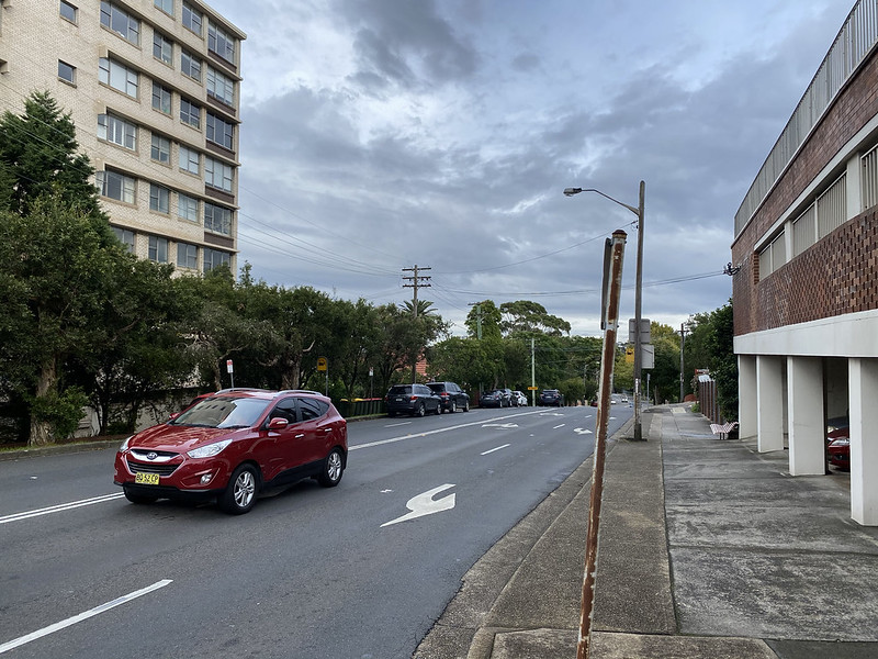
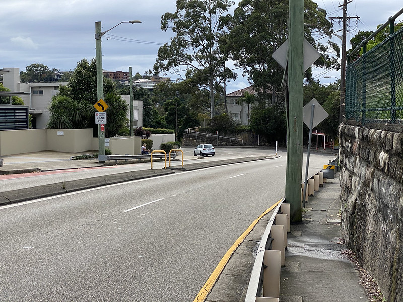
We start on River Road again, although this time further up the hill to the east of where we began walks 6. Greenwich Road and 8. Artarmon. This view looks down River Road to the west, towards that previous starting spot. We're in the suburb of Wollstonecraft.

River Road ends here, and most traffic turns up Shirley Road to the north. More uphill walking!

Approaching the top of the hill, on this side of Shirley Road is this old block of flats, "Elston Court". I assume the interiors are renovated and modern. "Elston Court" is right on the edge of Wollstonecraft.
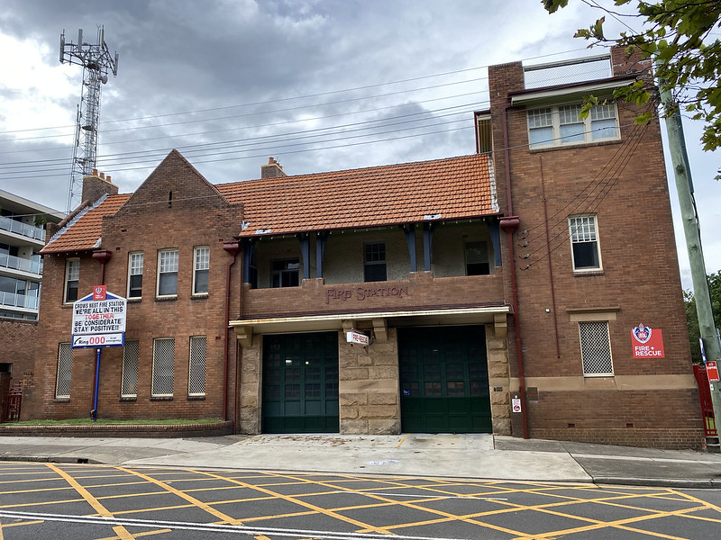
Directly across Shirley Road is the Crows Nest Fire Station, in this lovely old sandstone and brick building. It was built in 1907 in the Federation Free style, with additions in 1912. The building is heritage listed.
The fire station is not in Wollstonecraft, but in Crows Nest, as the suburb boundary here briefly runs down the middle of Shirley Road. The cross hatching on the street is a reminder for cars not to queue on this part of the street, so fire engines can get out.

At the top of Shirley Road is the Pacific Highway, which we saw a bit of in walk number 8. Artarmon, where it ran through St Leonards. This is a five-way junction: Shirley Road behind us, the Highway running left and right, Falcon Street leading off ahead on the right side of the Crows Nest Hotel, and Willoughby Road leading left of the Hotel (difficult to see, the exit into the intersection is behind the flags and the red traffic light at centre - there's no entrance to Willoughby Road from here).
The Crows Nest Hotel is a pub - traditionally many pubs in Australia are called "hotels", since many of them offered a few rooms of accommodation as well as a bar. It was built in 1927-28 in a mix of Inter-War Mediterranean and Art Deco styles, with elements of Egyptian Revival in the foyer interior. The hotel opened with a public bar and 33 bedrooms; the bar and saloon area were later expanded in 1929 when ground floor shops were incorporated into the hotel. The building is heritage listed. There's a better photo of the hotel near the end of future walk 11. North Sydney and St Leonards Park.
This intersection is at the highest point in the area, and has a good view if you can avoid the buildings. Edward Wollstonecraft (1783-1832) was one of the prominent early settlers in northern Sydney, and built his cottage just a little down the hill, a block back down Shirley Road (back across the cross street from where "Elston Court" now stands). He named it Crows Nest Cottage, for the views it had. Crows Nest later became the name of this suburb.
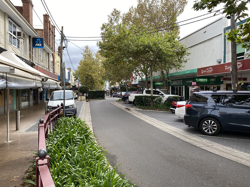
Crossing the Highway and turning into Willoughby Road, we see it's a quiet one-way street lined with high street style shops. This is a busy shopping area, with plenty of cafes and restaurants and a vibrant atmosphere. But it's very quiet today with the COVID restrictions.

Heading down the slope of Willoughby Road we pass The Stoned Crow, a more modern pub, in this renovated old residential building. These buildings were originally houses lining the street, but all have been converted to businesses now.

A little further down is Ernest Place, a small square with grass and trees, and a church on the far side at left. This is a popular area to sit and eat lunch or let small kids run on the grass.
The church is the Northside Baptist Church. The current building was built from brick in 1909 in Victorian Free Gothic style, adjacent to a previous small brick church built in 1900, and extended in 1965. The original 1900 building was used as the church hall until it was demolished in 1978. The church building is heritage listed.

Across the grass is the Crows Nest Community Centre. The rear of the Baptist church is visible at left.

Beyond the Community Centre is Big Music. This place sells musical instruments and offers music and singing lessons. This is where I learnt to play drums. They also have a couple of recording studios, if your garage band wants to cut a disc.

We're now on Alexander Street, running down the hill parallel to Willoughby Road. The commercial area of Crows Nest peters out and gives way to residences.

We turn right onto Devonshire Street, which goes uphill again...

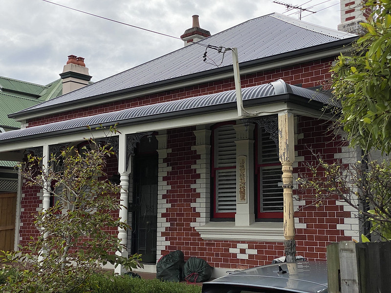
It has this lovely little Federation era cottage, built on a sandstone foundation.

At the end of Devonshire Street is this forbidding hedge and fence, pierced by a tiny gate and a sign saying St Thomas Rest Park.

Entering the gate, we find a path, grass, a gentle undulation in the terrain, trees, a park bench to sit on.

This grassy area is used by people exercising their dogs. But what's that in the middle?

It's a memorial tomb! It marks the resting place of Lieutenant James St Clair Bower, commander of HMS Sandfly. He was commanding a survey cruise of the Solomon Islands in 1880 when he and four of his crew were attacked and killed by natives. He was buried here, near where he lived at the time.

There are several historical graves here. St Thomas's Cemetery was dedicated in 1845 as one of the first cemeteries on the northern side of Sydney Harbour, and it contains many significant historical graves. In 1967 the land was granted to the local council, which declared the site a Rest Park, to preserve the graves and allow the community to use the land as a recreational area.

The largest monument is this impressive sandstone pyramid. It is the tomb of Elizabeth Berry, sister of Edward Wollstonecraft and wife of another prominent settler, Alexander Berry. Edward Wollstonecraft was also later entombed here with his sister.

Here's a plaque with some of the history of the site.
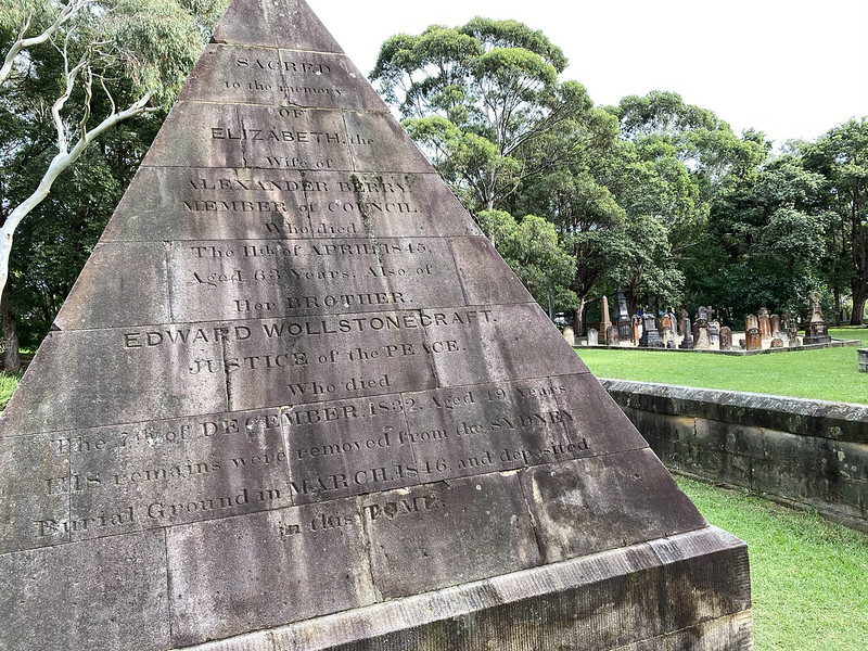
A more artistic shot of the pyramid and some graves in the background.

There's orange lichen on a lot of the old sandstone gravestones.

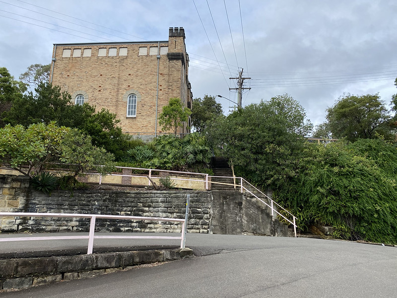
Also on the Rest Park grounds is Sexton's Cottage, built in 1848, and used for laying out bodies before burial in the cemetery. In 1984 it was turned into a community museum. St Thomas Rest Park and Sexton's Cottage are both heritage listed.

Behind Sexton's Cottage, we see the Rest Park (which we're still standing in, looking out over the fence) borders the Warringah Freeway. This is the main feeder route leading to the northern end of the Sydney Harbour Bridge and across the harbour to the south. We're going to walk across the overpass to the other side.

We've left the Rest Park, and this is a view from the overpass, north towards Chatswood (the tall office buildings in the background). You can also see two television transmission towers, and the verdigris green copper spire of St Leonards Catholic Church. We'll have a closer look at this church in future walk 14. Artarmon Grunge. By leaving the Rest Park on the eastern side, we've also left Crows Nest and entered the suburb of Cammeray.

Over the overpass on West Street is this duplex cottage with delightful coloured glass panels in the verandah side. We're now in the suburb of Cammeray, named after the native Cammeraygal tribe who lived in this area up to the arrival of Europeans.

Around the corner on Amherst Street is this stately old home, mostly hidden by foliage, which has been turned into a child care centre. The kids have made rainbows to help brighten the day of anyone walking past who is feeling a bit down because of COVID.
The home is "Tarella", well set back from an iron palisade fence by a large semi-formal garden. The house is a two-storey Victorian Italianate residence of brick, with a slate roof, built around 1874-1886. It was the residence of Sir Joseph Palmer Abbott, K.C.M.G., speaker of the New South Wales Legislative Assembly from 1880-1900. It was fully restored in the 1970s and the exterior and interior are in excellent condition.
In 1982, the then owner requested the land be rezoned to allow the house to be converted into offices of an architectural firm. North Sydney Council opposed the rezoning because of concern of loss of residential areas to commercial use. In retaliation, the owner threatened to have the house demolished. The council responded by requesting that the house be protected under the New South Wales Heritage Act. The Heritage Council advised North Sydney Council that it preferred the property to be rezoned to allow a commercial use compatible with the surrounding residential neighbourhood, but that if they became aware of an order for demolition they would consider protecting the property under the Heritage Act.
Apparently this didn't please the owner, who left the house empty. In 2001 it was sold to a childcare company, who in 2015 applied to convert the building into a childcare centre. Council turned down the application, but the company appealed the decision, which the NSW Land and Environment Court overturned in 2016, thus allowing the site to be operated as a childcare centre. All of this and more is written up on the home's heritage listing.

We hit Miller Street (left-right), a main road leading north through the suburb of Cammeray.

Miller Street contains the shopping area of Cammeray. Again normally busy, but empty today because of COVID.

We continue north along Miller Street, which dips steeply downhill past a school (on the right). It's before 9:30am, so the school zone speed limit of 40 km/h is active.
We continue down, down, the steep hill. Around this corner...

And suddenly we see Long Gully Bridge!

This is a magnificent old bridge, with crenellated castle-like towers on each of the two sandstone arches that stand astride the ends of the bridge. The bridge is also locally known as "The Suspension Bridge" despite it not being a suspension bridge, because when it was opened in 1892 is was in fact a suspension bridge, with a wooden roadway deck suspended from cables slung between the sandstone towers. The bridge is heritage listed.

The steel suspension cables and wooden roadway fell into disrepair and were deemed hazardous. The bridge was closed for renovation in 1937, and converted into a concrete arch bridge, which supports the current roadway from beneath, and was reopened in 1939. The original sandstone towers, no longer needed for the suspension cables, were left in place.

Walking out onto the bridge, you can see that it spans a very deep ravine. That's a soccer field down there. The northern side of the bridge is the suburb of Northbridge. But that's too far for me to walk today, so I turn back around and head south back into Cammeray.

Here's the view beginning to walk back south. We have to go back up that hill...

Rather than take Miller Street again, we turn into a side street. The land is so steep that this cross street is tiered down the middle.
We're heading up those steps. The brick building at the top is interesting. We'll have a closer look in a minute.

But looking back from the top of the steps gives us this view across the ravine, and we can see the towers of Long Gully Bridge just left of centre. We're already above the height of the tops of the towers.

That brick building is an electricity substation. Or as the sign indicates, an "Electric Light Substation". The small towers at the top are crenellated, to complement the nearby bridge towers. It was built in 1915 in the Inter-War Gothic style, with Tudor-inspired towers and an Art Nouveau lettering plaque carved from sandstone above the smaller entrance door.

As this historic plaque indicates, the substation was built in 1915, and supplied all of the electricity to northern Sydney until 1925. Since then it's been converted to a mere local substation. The building is heritage listed, and even has its own Wikipedia page.
Up Bellevue Street is this interesting two-tone brick cottage.
And this otherwise nondescript block of flats with a cool white Art Deco entrance.
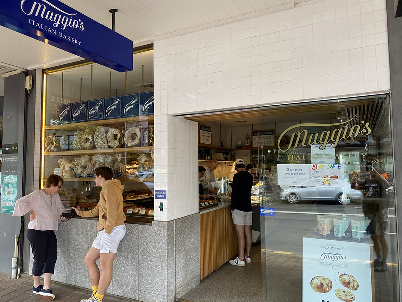
We're back in the Cammeray shopping area now, and I stop here at Maggio's Italian Bakery for a fortifying snack. Maggio's is the best bakery I know of within walking distance - although it's a long walk to get here. Only 3 customers are allowed inside at once due to COVID-19 safety social distancing regulation.

I mean look at that!

I decided on a slice of the baked ricotta cheesecake. I need something to restore all the calories lost through walking! It's light for a cheesecake and absolutely delicious, by the way.

We cross through the shopping area and behind it we find North Sydney Leagues Club. Opened in 1955 this club was to provide a social venue for supporters of the North Sydney Bears rugby league team, one of the founding Sydney Rugby League teams. Over time, the team foundered and has become defunct as a premier league team, although I believe they still field teams in minor local competitions. The club continues, however, as a social epicentre for the region (although currently closed due to COVID).
We walk west along Palmer Street, another street affected by the sloping terrain. I'm standing on the opposite footpath to the one you can see below. Behind the houses is a deep gully, which runs down to the right, back towards Long Gully Bridge.

But the street leads to this on ramp to the freeway, and an underpass, that we walk through to return to Crows Nest.

Back in Crows Nest we are faced with climbing the hill back to the top of the suburb, up Alexander Street. We'll soon retrace our steps back the way I came, so we end the photos here.

Map of this walk. Starting at the bottom left, heading diagonally to Long Gully Bridge at top right, then south and west, crossing over the outbound walk.