Mission Dolores
[ << previous | index | next >> ]
We slept in a little this morning and got up about 07:30. After breakfast and showers we packed the car again and checked out of the Motel 6 at Gilroy. We planned a rough itinerary ahead and listed four Motel 6s we could stay at along the rest of our trip, then asked the lady at reception if she could book them for us.
I expected her to punch a few numbers into a computer and have it all done, but she had to call them all individually by phone. She called one at Coos Bay and made the reservation. Then she tried one at Lincoln City and got someone who was being a bit thick and insisting on a ZIP code even thought we were from Australia. After getting through the address details in gory detail she gave my Amex number to hold the reservation and the woman on the other end said they didn't take that! The woman we were talking to rolled her eyes and explained to us that all Motel 6s took Amex. By this time the second woman at the reception desk was getting into it, saying the woman at Lincoln City must be new. The two were laughing it up whenever the first one put Lincoln City on hold, and apologising profusely to us for the trouble. Finally I told her to forget Lincoln City and try Portland. The person there took the reservation and gave us a confirmation number within two minutes. Then the woman had to stop to help another guest for a minute and we decided not to have her call the Yakima motel, as we wanted to be on our way and figured it would be easier just to show up and check in.
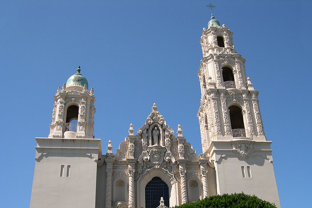
So we packed up and drove off, joining highway 101 north to San Jose and San Francisco. The freeway drive was eventless and we took the Cesar Chavez Ave exit in San Francisco and drove along that street to Dolores St, where we turned to go to the Mission Dolores - the oldest standing building in San Francisco. Driving past it I despaired of finding a parking spot in the clogged streets. We turned left right after the Mission, then circled right around the next block and approached it again from the other direction, when I spied a parking spot in the street just two cars from the intersection where the Mission was located! It was a tight squeeze for my first ever reverse park driving on the wrong side - probably the tightest reverse park I've ever tried. Michelle got out and directed as I inched forward and backward into the spot. After about five reverses and forwards I had squeezed the car into a spot barely big enough for it! I am a driving legend!
Mission Dolores |
We crossed 16th St and admired the Mission exterior, then went in for the self-guided tour. This took us through the chapel into a small courtyard and then into a beautiful old basilica. There were men in the process of decorating the basilica with large palm leaves, presumably for Palm Sunday services. From there we looked in a museum room full of artefacts of the old Mission and then across into an old cemetery garden. There were gravestones from the 1800s; the earliest we found was 1801.
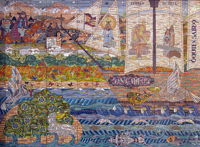 Mosaic inside Mission Dolores |
We left the Mission and drove up to Twin Peaks for a gorgeous view of San Francisco. The weather was close to perfect - not a cloud, not a wisp of fog or mist - it was probably the best day I've ever seen in San Francisco. The view was spectacular.
Then we drove again towards Golden Gate Park, but looked for somewhere to stop for lunch. When we reached Irving St on 7th Ave, we saw a lot of shops, so decided to stop. And by a miracle we saw a free parking meter immediately after the Irving St intersection! It even had 12 minutes still on it! We put in a couple of dimes to give us more time and went for a walk down Irving St. We found a small coffee shop that had bagels and muffins and stopped for a light lunch. Michelle had a bran and pineapple muffin and I had a bagel with salmon cream cheese and a bear claw to take away for later.
Then we drove ahead down 7th Ave, intending to go straight into Golden Gate Park, but the street didn't let us drive straight across Lincoln Way and we had to turn right on to it. We couldn't turn left into the park anywhere and ended up on Oak St driving away from the park! We finally managed to turn around and headed into the park on JFK Drive. We stopped in front of the flower gardens near the Conservatory of Flowers and had a quick look around. We drove around half of Stow Lake and then exited the park on 25th Ave heading north to the Presidio.
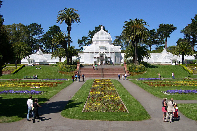 Conservatory of Flowers, Golden Gate Park |
There we stopped near Fort Point to look at the Golden Gate Bridge and take some final photos in San Francisco. Then we drove up to the entrance to highway 101 north and over the bridge.
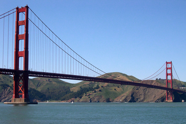 Golden Gate Bridge, from Fort Point |
A few miles down the freeway we turned off on to Highway 1. I commented to Michelle that all the hard navigation was over and we only had to follow this one road all the way to Oregon. As we followed the road, I noticed a shopping area and turned off into a carpark to find a supermarket. There was one there, so we bought some new cereal and some fruit (apples and pears). Then we left again, taking an exit from the carpark on to a cross street and turning back on to what I thought was highway 1.
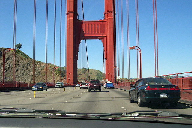 Driving north across the Golden Gate Bridge |
We continued driving and noticed the street getting more and more suburban looking until finally it ended at a T-junction, with no indication where highway 1 was. After a couple of turns I concluded we were hopelessly lost and parked to ask directions. I went into a City Hall that turned out to be for the town of Mill Valley. A man in there gave me directions to Stinson Beach, which was at least on highway 1, but he said it missed Muir Woods but was "the best way to go". We followed his directions and ended up on a narrow winding road that went up into the mountains and down on to the ocean side. Eventually we reached highway 1 and turned right to start our drive up the coast.
We stopped in a tiny town called Tomales when I saw a red phone booth outside a store there. It was imported from the UK - it had crowns on it still - and was fastened shut, but we got photos to add to my collection. I also took some shots of an interesting church there. Then we continued our drive north.
We didn't really stop anywhere else except a few vista points for photos as we were determined to make it at least as far as Jenner by sunset. We were forced to slow down at one point by a fire burning in the brush and forest right next to the road and being attended by several fire trucks. Further along we also saw a car being loaded on to a tow truck and were again forced to slow down as they only let traffic past in one lane shared between both direction.
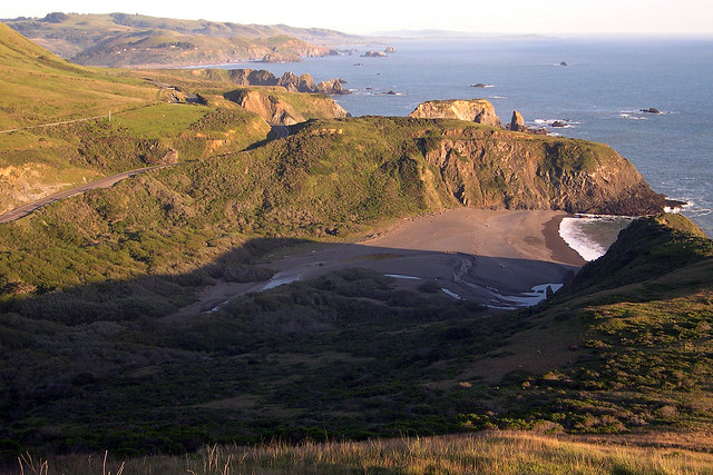 View from Highway 1 north of Jenner |
We drove through the small town of Jenner almost before blinking and decided to continue on towards Gualala as the sun was still up. It set beautifully over the ocean as we continued driving, casting orange then pink light over the coastal forests and hills. We pulled into Gualala and found the Gualala Country Inn right at the start of town. It looked nice so we checked in and found a very nice room awaiting.
We unpacked the car and then went walking to find dinner. We decided on a small pizza place not far away and ordered a small Home Choice (sort of supreme) and pesto veggies. The pizzas were really good and we scoffed the lot. Then we walked to the supermarket a couple of doors down and bought some Ben & Jerry's Phish Food ice cream for me for dessert. We walked back to our room and relaxed for the night.
[ << previous | index | next >> ]